
The US is far behind China and Europe on floating wind turbines
(Sustainabilityenvironment.com) – After unlocking the first offshore block wind auctions off Maine, New York and the West Coast, Biden tries to accelerate with the floating wind turbines. Yesterday the president of the United States announced 15 new GW of installed capacity with floating technology by 2035.
A forced move to fully exploit the potential of energy from the wind. “Conventional offshore wind turbines can be attached directly to the seabed in shallow water near the east coast and the Gulf of Mexico,” explains the White House. “However, deep water areas that require floating platforms are home to two-thirds of America’s offshore wind potential, including along the west coast and the Gulf of Maine”.
An update of Doe’s study of the potential for star and stripe wind power in mid-August this year shows that between the two ocean coasts, the Gulf of Mexico and the great lakes to the north, the United States would have a huge estimated potential: 1.5 TW of installed capacity of traditional offshore wind and well 2.8 TW for floating wind.
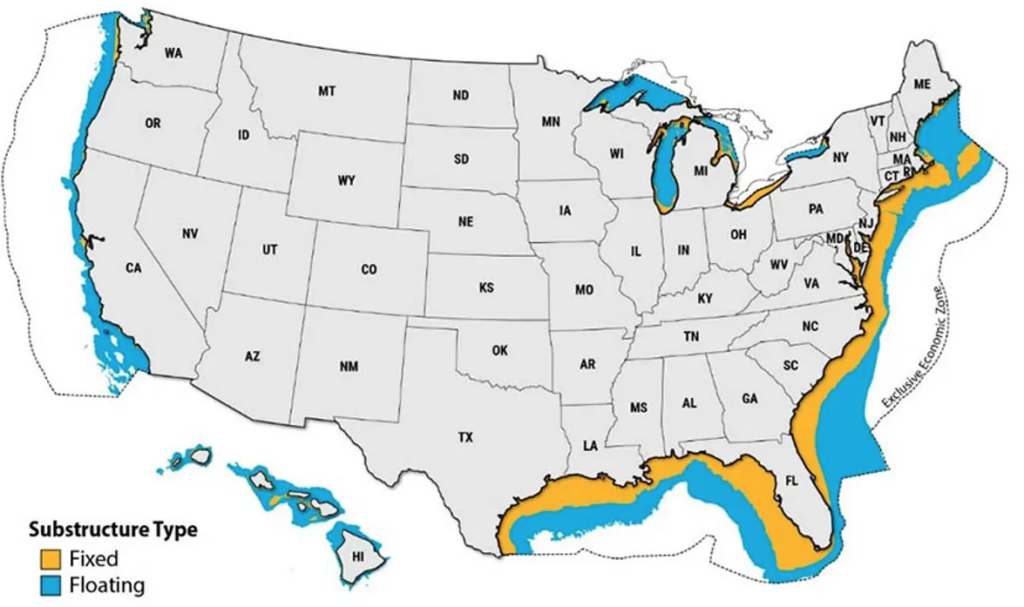
crediti: NREL
Potential that remains for the moment almost completely untapped. Washington is lagging far behind its main competitors – China and Europe – in wind energy. But the falling costs of this technology are making it more and more attractive. In 2021, the estimated level energy cost (LCoE) for commercial-scale offshore wind projects in the United States fell by 13%, rising to an average of $84/MWh, with a range of $61 to $116/MWh.
Read also The largest floating photovoltaic in Europe? It is in Portugal
With this initiative, the White House estimates that it will be possible to reduce floating technology costs by more than 70% by 2035, up to $45 per megawatt hour. And bridge the gap with major installer countries. “The actions taken today will lead the United States to be a world leader in offshore floating wind technology. Globally, only 0.1 GW of floating offshore wind has been installed, compared to over 50 GW of fixed-bottom offshore wind. America will seize this opportunity to be at the forefront of floating offshore wind technologies,” reads a note from the presidency.